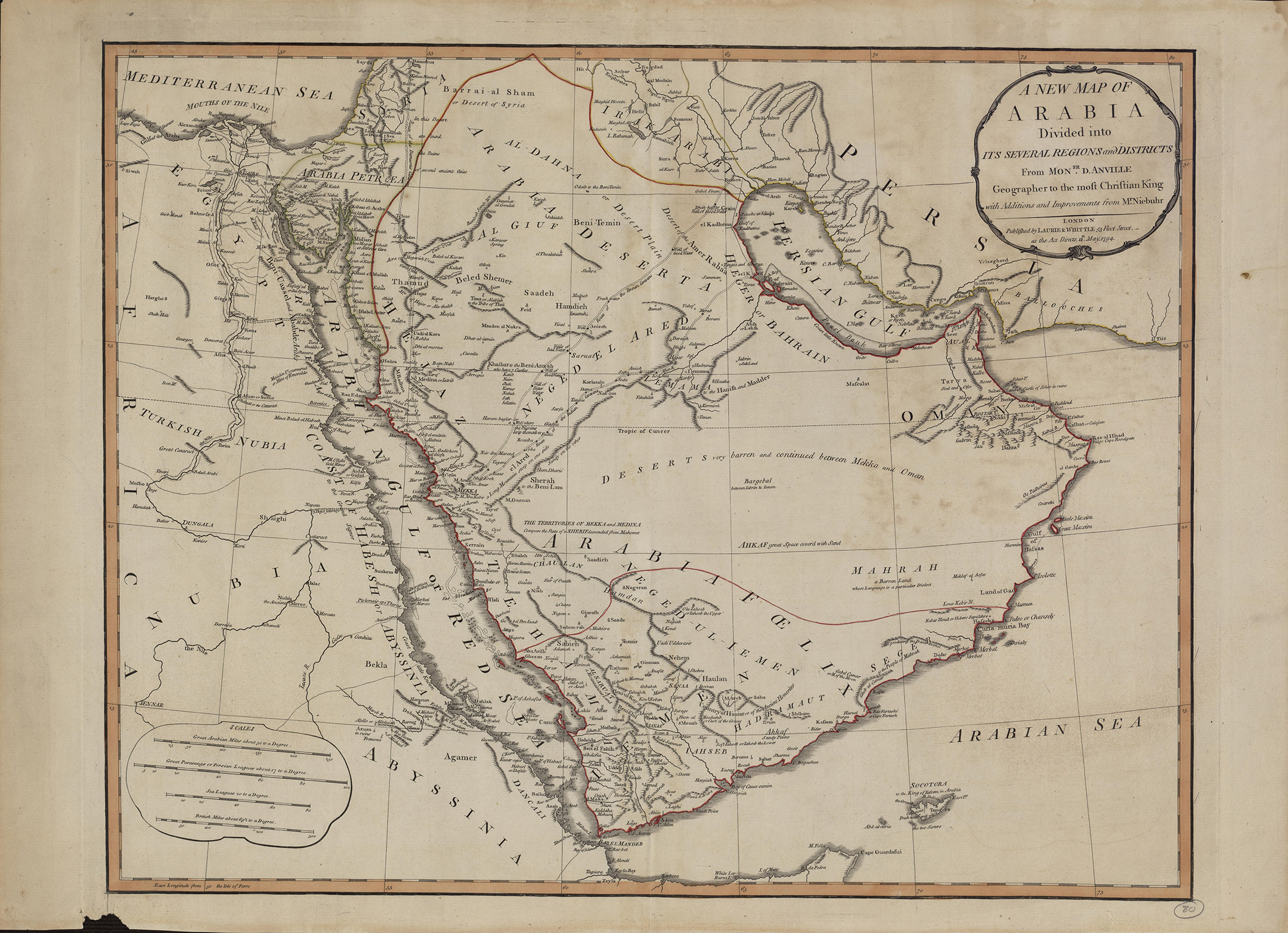
Other Title A New Map of Arabia: Divided into its several regions and districts Summary This map of Arabia, published in London in 1794, is an English translation of a map by the French cartographer and geographer Jean-Baptiste Bourguignon d'Anville (1697-1782). Appointed the first geographer to the king of France in 1773, d'Anville was one of the most important mapmakers of the 18th century, known for the accuracy and scientific quality of his maps. The work presented here is said to contain "Additions and Improvements from Mr. Niebuhr," a reference to Carsten Niebuhr (1733--1815), a German-born Danish explorer and civil engineer who journeyed through Arabia and Yemen in 1762--67 and whose Travels through Arabia and Other Countries in the East (an abridged translation from the original German) was published in Edinburgh in 1792. The map includes cities and towns, coastlines, caravan routes to Mecca, wells, mines, and other geographic features, and brief notations on some of the peoples and kingdoms of the Arabian Peninsula. Qatar is shown as "Catura," with the notation "Coast little Known" just south of its location. Four distance scales are given: great Arabian miles, great parasangs or Persian leagues, sea leagues, and British miles. The map was published by the London firm of Laurie & Whittle, a partnership of the engraver Robert Laurie (circa 1755-1836) and print seller James Whittle (1757-1818) that was known for its accurate maps and nautical charts. Names Anville, Jean-Baptiste Bourguignon d', 1697-1782 Creator. Niebuhr, Carsten, 1733-1815 Contributor. Created / Published London : Laurie & Whittle, 1794. Headings - Djibouti - Eritrea - Ethiopia - Sudan - Iran, Islamic Republic of - Bahrain - Egypt - Iraq - Israel - Jordan - Kuwait - Oman - Qatar - Saudi Arabia - United Arab Emirates - Yemen - 1794 - Arabian Gulf - Arabian Peninsula - Persian Gulf - Red Sea Notes - Title devised, in English, by Library staff. - Original resource extent: 1 map ; 46.5 x 59 centimeters. - Original resource at: Qatar National Library. - Content in English. - Description based on data extracted from World Digital Library, which may be extracted from partner institutions. Medium 1 online resource. Digital Id https://hdl.loc.gov/loc.wdl/wdl.12891 Library of Congress Control Number 2021668549 Online Format compressed data image LCCN Permalink https://lccn.loc.gov/2021668549 Additional Metadata Formats MARCXML Record MODS Record Dublin Core Record IIIF Presentation Manifest Manifest (JSON/LD)